
From Esquire, by Charles P. Pierce:
This is beyond belief. Even by this guy’s standards for cheap lying, this is off the charts, across the floor, down the storm drain, into the river, and long gone off up the gulfstream.
Remember the other day when the president* said that Hurricane Dorian posed a threat to Alabama, and then the National Weather Service told all the people in Alabama to relax because the president* didn’t know what he was talking about, so they all shouldn’t run off to the Piggly Wiggly to buy 250 loaves of bread? Whereupon, the president* expressed his annoyance at his own National Weather Service for its role in helping him look foolish? Again. (Maybe it was just their turn.) This resulted in a couple of days of social-media snark directed at the president*s Very Great Brain.
Cut to Wednesday morning in the Oval Office. From NBC News:
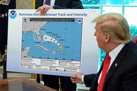
The map Trump displayed was the same as a model produced by the National Oceanic and Atmospheric Administration last week showing the hurricane’s projected path cutting through central Florida— with one key difference. Where the original projection ended, a smaller, black circle that appeared to be drawn in sharpie was produced to include Alabama in the model.
Sharpie? He either doctored—or had doctored—the map with a freaking Sharpie? I wonder if he did it himself or contracted out the work to the Department Of Embarrassingly Clumsy Fakes, led by Secretary Of Embarrasingly Clumsy Fakes Epstein’s Mother.
A Sharpie.
This is just insane.

How much do I love this?!
LikeLiked by 1 person
Why is anyone surprised about? He’s got to be right even if he cheats and uses sharpies to do it.
LikeLiked by 1 person